The 10 Best Hikes In Banff National Park For Summit Views
If you’re highly adventurous and planning to visit Banff National Park for a outdoorsy hiking holiday then there are a lot of great hikes to choose from.
Whether you are a beginner, intermediate or expert hiker you can easily find an amazing hike with stunning panoramic views that will take your breath away.
The 6,641 square kilometres of Banff National Park is full of unforgettable glacial lakes, waterfalls and mountain peaks but if you only have a few days to hike then you’re going to want to experience some of the best the Canadian Rockies have to offer.
I have had the good fortune to spend many years exploring the backcountry and mountaintops of the Canadian Rockies and in this Banff Hiking Guide, I want to share with you some of the most beautiful day hikes you can do to get away from the crowds of mass tourism in Banff National Park.
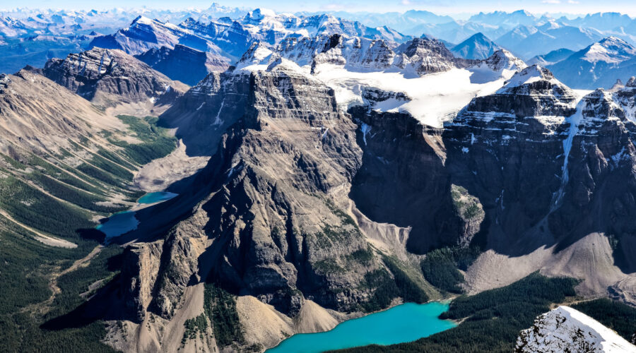
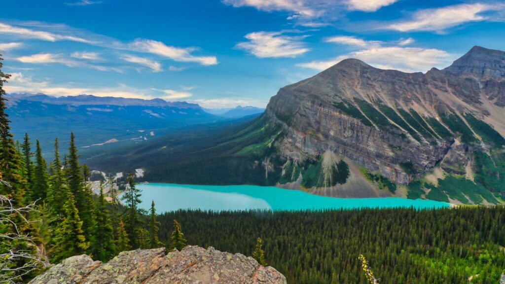
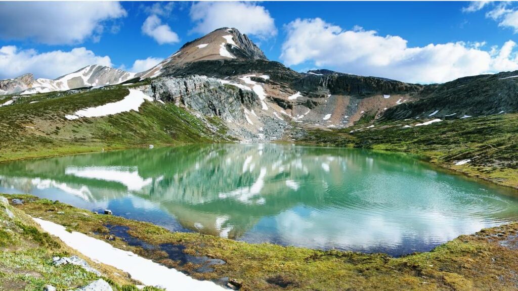
1. Moraine Lake, Larch Valley And Sentinel Pass
Time: 4 – 6 Hours
Distance: 11.1 km (Out & Back)
Elevation Gain: 749 m
Difficulty: Intermediate
Trail Map: Alltrails
No summer visit to Banff National Park is complete without a climb up the Rockpile to the 3 panoramic viewpoints overlooking Moraine Lake. The ever-changing cobalt blue and technicolour rock flour of this stunning natural wonder makes it perhaps the single most beautiful place in Canada.
While this is truly one of the most awe-inspiring places in Banff National Park, it’s also very crowded with tourists. To get away from the crowds and the drone of tour bus motors, I recommend hiking up to Larch Valley and then on to Sentinel Pass for an epic view of Paradise Valley.
On the switchbacks up to Larch Valley you will reach a bench, at this crossroads, I recommend going 10 minutes along the Eiffel Lake trail where few people go to get a great view of the backside of the Valley of the Ten Peaks.
If you’re an expert hiker and you’re looking for a challenge you can continue up from Sentinel Pass to Mount Temple, which is the third highest peak in Banff National Park and a 10-12 hour leg crusher that can be very dangerous in poor weather conditions.
2. Lake Louise, Big Beehive And Plain Of Six Glaciers
Time: 8 Hours
Distance: 18.2 km
Elevation Gain: 920 m
Difficulty: Intermediate
Trail Map: Alltrails
While Lake Louise is stunningly beautiful, it’s also a mecca for overtourism that may make you question your faith in humanity and the mindlessness of people in the age of social media and smartphone addiction.
To get away from the crowds, I recommend taking the trail up to the Lake Agnes Teahouse, which is the most popular hike in the Lake Louse area but it’s worth it, especially if you start early before it gets crowded.
From Lake Agnes, the crowds will disappear as you climb further up to the Big Beehive. From here you will get one of the best views of Lake Louise. If you’re an experienced hiker, I also recommend going a little further up to the Devil’s Thumb which is an even better viewpoint.
From the Big Beehive, you can make your way down to the end of the Lake Louise lakeshore and continue up to the Plain of Six Glaciers. Here you will be below the massive glaciers on Mount Victoria and there is another quaint teahouse with a picturesque backdrop worth visiting.
Doing all these hikes together can make for a long day but it’s probably a good idea if you want the full Lake Louise experience because parking at Lake Louise is such a nightmare.
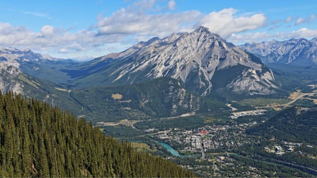
3. Cascade Mountain Overlooking The Town of Banff
Time: 8-10 Hours
Distance: 18.5 km
Elevation Gain: 1,635 m
Difficulty: Expert
Trail Map: Alltrails
This iconic mountain towers over the town of Banff and creates the backdrop for one of the most beautiful fairy-tale mountain towns found anywhere in the world.
This is a long hike but worth it if you want to see the best view of the spectacular Banff Valley known as Mînî hrpa by the local Stoney Nakoda meaning “The Place Where The Water Falls”. Banff has been an important summer trading area for First Nations tribes on both sides of the massive Rocky Mountains and Clovis points have been found along the Vermillion Lakes dating back over 10,000 years.
The trail up Cascade Mountain starts from the Mount Norquay ski resort and on the way up the upward ridge along the Cascade Amphitheatre is spectacular. From the top of Cascade Mountain, you can see one of the best views of Mount Rundle, the meeting of major migration corridors around Banff and the azul waters of Lake Minnewanka.
This is only for experienced hikers with excellent fitness as it’s a long day hike with a lot of elevation gain. If you’re looking for a quick hike, the most popular hike overlooking the town of Banff is Tunnel Mountain (although I much prefer the Stoney Nakoda name Sleeping Buffalo Mountain). This is a very busy trail but it offers excellent views for only 1-3 hours of hiking.
4. Mount Rundle And The Dragon’s Back
Time: 6-7 Hours
Distance: 15 km
Elevation Gain: 1,706 m
Difficulty: Expert
Trail Map: Alltrails
The other iconic mountain towering over the town of Banff is Mount Rundle. The upper part of Mount Rundle that is above the treeline is called the Dragon’s Back and it is a terrifying place that is both awesome and awful at the same time.
Why? Because it’s a windy scramble and it can be terrifying to summit this mountain so it’s reserved for only experienced hikers who think they can tame the dragon.
From the top of the Dragon’s Back on Mount Rundle, you can look over the abruptly sheered cliffs that abruptly drop 1,000s of feet giving the mountain a unique shape found nowhere else in the world that I know of.
Alternatively, if you’re looking for an easier hike with awe-inspiring views of the Dragon’s Back you can take the Banff Gondola, walk the boardwalk for the panoramic views of Banff and hike down the backside through Sundance Canyon to return to the town of Banff.
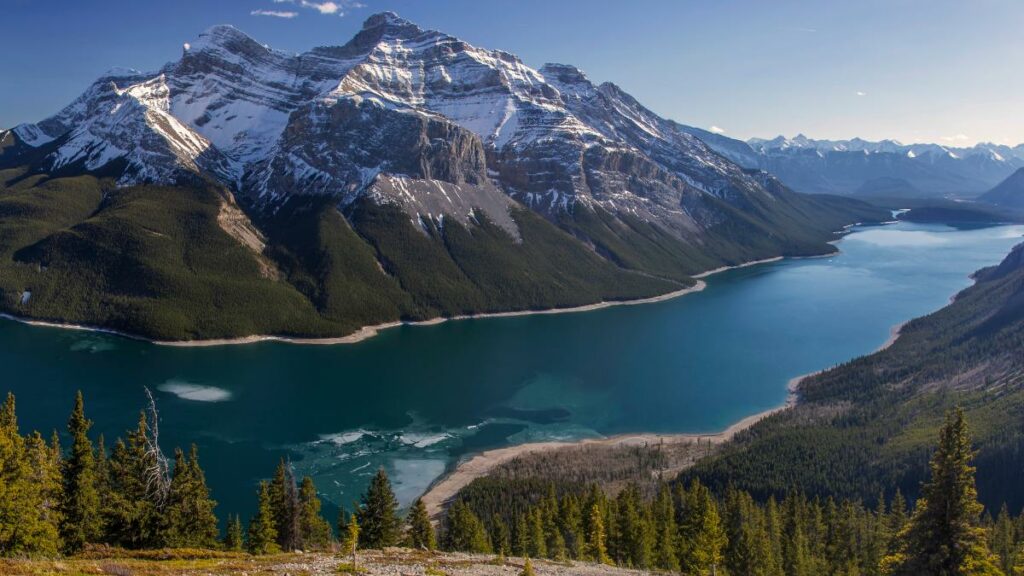
5. Aylmer Lookout Overlooking Lake Minnewanka
Time: 8 – 10 Hours
Distance: 23.2 km
Elevation Gain: 1,040 m
Difficulty: Expert
Trail Map: Alltrails
The best view of Lake Minnewanka is from the Alymer Lookout, which offers breathtaking 360° views at the summit. This isn’t a technically difficult hike but it’s a very long hike and the last part is quite challenging to climb up to the viewpoint.
This is an important grizzly bear habitat so every summer between July 10 and September 15 you must hike in groups of at least 4 people and carry bear spray. Certain times of the year this trail is closed to protect the local Grizzly Bear population so check before you decide to hike this trail.
Before the introduction of horses and buggies and later railways and highway transportation through the Bow Valley, the far end of Minnewanka known as the “Devil’s Gap” was one of the main transit routes by canoe through the rugged terrain of the Canadian Rockies.
This is a historic crossroads of First Nations people and it retains the Indigenous name given to it by the Stoney Nakoda “Lake Minnewanka” meaning the “Lake of Spirits”, which is one of the most fascinating ancient legends of the Rocky Mountains.
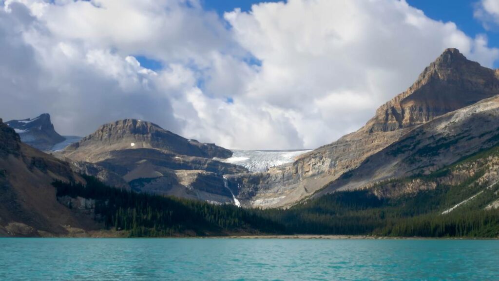
6. Bow Glacier Falls And The Onion
Time: 8 Hours
Distance: 17.5 km
Elevation Gain: 883 m
Difficulty: Expert
Trail Map: Alltrails
About 30 minutes from the beginning of the southern end of the Icefields Parkway, you will experience the majesty of Bow Lake, one of the largest and most beautiful lakes in Banff National Park.
While the tourist pull-off is usually crowded from morning to night, once you get past the historic red-roofed Bow Lake Lodge the crowds start to thin out fast. On the far shores of picturesque Bow Lake, you can hike up to Bow Glacier Falls which pours off of Iceberg Lake and the massive Bow Glacier.
If you’re looking for a challenge, you can continue up to the Onion, which offers incredible views of the Bow Glacier, Iceberg Lake and the many waterfalls pouring out of the mountainous heavens above.
From the valley, you can only see the toe of the Bow Glacier and the Wapta Icefields. Up in the upper alpine, it feels like a glacial Mordor and the sheer size and scope of this massive icefield will take your breath away.
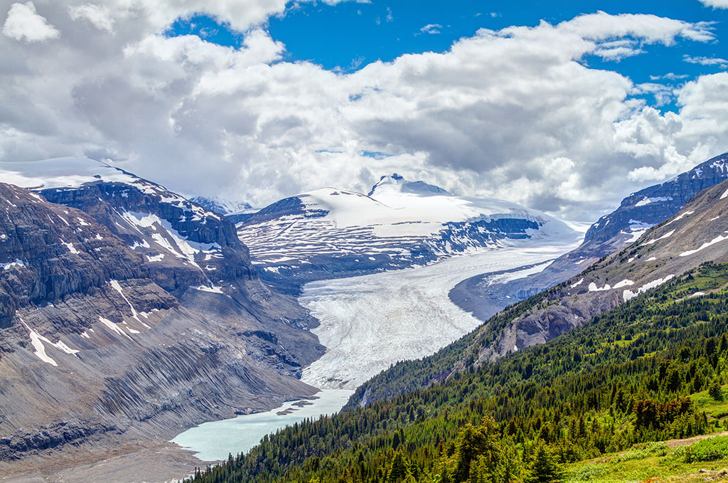
7. Parker Ridge Overlooking The Saskatchewan Glacier
Time: 2-3 Hours
Distance: 6.4 km
Elevation Gain: 343 m
Difficulty: Intermediate
Trail Map: Alltrails
Parker Ridge is one of my favourite hikes along the Icefields Parkway. You will see the trailhead and parking lot just before you reach the Colombia Icefields Centre and the Athabasca Glacier on the edge of Jasper National Park.
A series of switchbacks leads up to a panoramic ridge overlooking the Saskatchewan Glacier and the headwaters of the Saskatchewan River, which flows east through Edmonton across Canada’s plains to Hudson’s Bay and the Atlantic Ocean.
From the top of Parker Ridge, you can also see a beautiful glacial lake and a series of waterfalls pouring down from the upper reaches of the mountains from snowmelt so the best time to do this hike is in the summer.
This is also a great area for high alpine wildflowers especially on the lower slopes you hike up through to Parker’s Ridge.
While most people just do the 2-3 hour hike to Parker Ridge, you can extend this hike and double the length by continuing west along the ridge top toward Mount Athabasca.
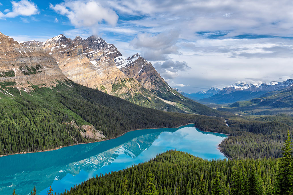
8. Bow Summit Overlooking Peyto Lake
Time: 2-3 Hours
Distance: 6.8 km
Elevation Gain: 287 m
Difficulty: Intermediate
Trail Map: Alltrails
Can you see the shape of the animal that Peyto Lake resembles? I’ll leave it up to your imagination as there are perhaps many different answers.
The hike to Bow Summit offers one of the most famous views in Banff National Park. While most people experience the natural wonders of Peyto Lake and the waterfalls pouring off the fast-shrinking Peyto Glacier from the busy lookout deck that is 15 minutes from the parking lot there’s a much better view with no crowds on Bow Summit.
The route up Bow Summit goes beautiful alpine wildflower meadows in the summer. Take some time to mindfully hike and just enjoy the full spectrum of purple, red and yellow flowers and I recommend doing this hike to catch the spectacular sunsets or Northern Lights displays over Peyto Lake.
From the top of Bow Summit, you will have a sweeping panoramic view of Peyto Lake and far down the Mistaya River Valley up to 100 km in the distance. This hike can be down throughout the year if you have microspikes but some avalanche zones can make it risky in the winter.
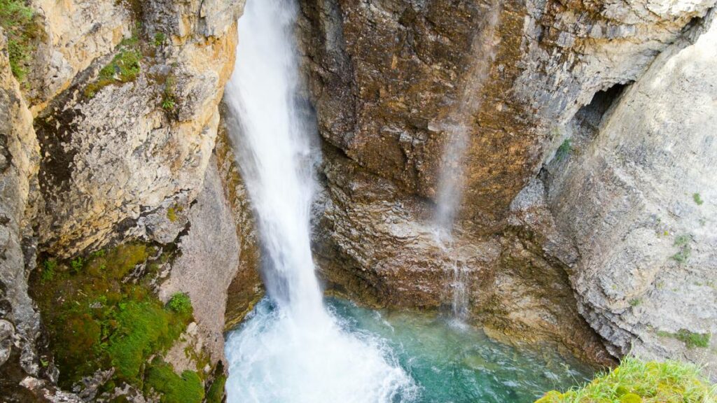
9. Johnston Canyon And The Ink Pots
Time: 4-5 Hours
Distance: 11.3 km
Elevation Gain: 579 m
Difficulty: Beginner
Trail Map: Alltrails
Time: 4 – 6 Hours
Difficulty: Intermediate
Johnston Canyon is one of the busiest hikes in Banff National Park for a reason but it’s important to start as early as possible to avoid the crowds.
Johnston Canyon is an easy hike with 7 waterfalls and some interesting caves with great waterfall views. From the Upper Waterfalls at Johnston Canyon begins the real fun hiking up to the Ink Pots, which are a series of colourful ponds surrounded by wildflower meadows in the Mystic Valley above the canyon.
The Ink Pots are small mineral springs that can be slightly different colours depending on the time of year. This is a popular hike in the winter but the trail becomes very slippery and you can hike with microspikes on your hiking boots for better traction.
The Upper Valleys is a gateway into some deep backcountry valleys in Banff National Park that are popular for multi-day trekking expeditions.
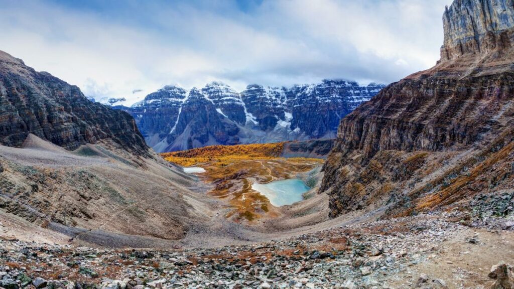
10. Helen Lake And Cirque Peak
Time: 8-9 Hours
Distance: 16.1 km
Elevation Gain: 1090 m
Difficulty: Expert
Trail Map: Alltrails
Just before Bow Lake on the Icefields Parkway, you come across from the Crowfoot Glacier glacier viewpoint and across from that busy tourist pulloff you will find the parking area for Helen Lake.
This is a classic Banff National Park hike with beautiful scenic views of Dolomite Peak, Wapta Icefields, Peyto Lake, as well as the valley of the Bow River that begins at Bow Lake and flows southeast through Lake Louise, Banff and Calgary.
The trail to Helen Lake and Cirque Peak begins with an incline section through beautiful alpine forests for the first 3 kilometres and then it is relatively easy up through wildflower meadows to Helen Lake. After the lake, it’s pretty much a steady climb through loose scree as the trail reaches the ridge and then it’s a challenging climb up to the top of Cirque Peak.
If you manage to make it to Cirque Peak, you will be rewarded with one of the best views in the Canadian Rockies with sweeping panoramic views across the valleys to Bow Lake and the Bow Glacier.
Frequently Asked Questions About Hiking In Banff National Park:
What is the best time to visit Banff National Park?
In high season from June to September, popular places in Banff National Park can feel overrun by mobs of tourists and tour bus groups.
We help you customize a Banff hiking tour to avoid the crowds during peak season.
Banff is also just as beautiful outside of peak season, with April, May and October also being good months to visit and go hiking in the national park.
Where does the name Banff originate from?
Banff became Canada’s first national park in 1885 after 3 railway workers discovered the Cave and Basins hot springs and decided to build a small hotel there to attract tourists.
The Canadian government stepped in and created a protected reserve that eventually became what we know as Banff National Park today.
The name Banff was chosen by a number of the town’s Scottish founders who were from Banffshire, Scotland (the name in Gaelic can be translated as holy woman).
The local Stoney Nakoda peoples call the area Minhrpa meaning “Mountain Where The Water Falls” after Cascade Mountain which resembles a cascading waterfall of rock, snow and ice — along with a large waterfall on the eastern-facing rock faces.
What is the First Nations history of Banff National Park?
Over 450 indigenous archaeological sites have been discovered in Banff National Park that involve points, stone tools, spears, butchered bones, hearths, house pits and pictographs.
The oldest archeological discovery in Banff National Park was a Clovis point found along the shores of Lake Minnewanka just outside of Banff, dating to 13,000 years ago. The Stoney Nakoda refer to the lake as “Minn-waki” or “Lake of the Spirits”, a place they both respect and fear for its resident spirits.
Where are the best places in Banff for seeing wildlife?
Banff is one of the best places in the world to see large mammals in their natural habitat.
There are 56 different mammal species in Banff, including Black Bears, Grizzly Bears, Bighorn Sheep, Mountain Goats, Lynx, Moose and Wolves.
Some of the best places to see wildlife in Banff National Park are:
- The Lake Minnewanka and Two Jacks Lake route
- The Columbia Icefields Parkway
- Sulphur Mountain in Banff
- The Bow Valley Parkway between Banff and Lake Louise
- Backcountry hiking trails away from crowds
What is the highest mountain peak in Banff National Park?
Mount Forbes is the highest peak entirely within Banff National Park at 3,612 metres (11,851 feet). You can see the summit of Mount Forbes from the Icefields Parkway at the Saskatchewan River Crossing on a clear day.
The highest peak in the Southern Canadian Rockies is Mount Assiniboine 3,618 metres (11,870 feet) and it can be seen from the Sunshine Meadows hike that is a 20-minute drive from the town of Banff.
The highest peak in the Northern Canadian Rockies is Mount Robson at 3,950 meters (12,970 feet) and it is found about an hour west of Jasper National Park where it towers over the highway leading into British Columbia.
I have been running mindful hiking retreats for the last 7 years that integrate mindful awareness, experiential learning and community building practices.
I have been an experiential learning designer for over a decade through my company DIY Genius, which helps creative people productize their expertise.
I love flying my drone and sharing my adventures on my Instagram.
- 10 Best Multi-Day Hikes In Banff And The Canadian Rockies - April 18, 2025
- The 10 Best Hikes At Lake O’Hara In Yoho National Park - April 18, 2025
- The 10 Best Hikes In Banff National Park For Summit Views - April 18, 2025